RV Investigator maps the far northern Great Barrier Reef
A transit voyage by CSIRO research vessel (RV) Investigator to reposition the vessel from Cairns to Darwin (IN2022_T01), was an opportunity to continue multibeam mapping along the far northern Great Barrier Reef continental margin. Dr Robin Beaman from James Cook University also joined the voyage team of ASP crew and CSIRO technical staff, including the Geophysical Survey & Mapping team, to help guide the mapping priorities during the week-long transit.
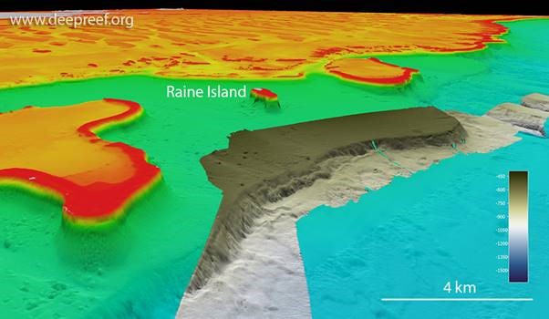
An 18 km long by 5 km wide section of a deep platform was mapped to seaward of Raine Island, one of eight 300-500 m tall detached reefs, by adding to the previous mapping efforts by the Schmidt Ocean Institute’s RV Falkor in 2020/21. This deep ledge, now 100% mapped, and the steep scarp that drops into the adjacent basin, helps to explain the growth positions of these unusual detached reefs and their long growth history over geological time.
RV Investigator is part of the Marine National Facility, national research infrastructure operated by CSIRO on behalf of the nation.