Transit mapping across the Great Southern Ocean; geomorphic insights
Rachel Nanson and Aero Leplastrier, Geoscience Australia
The CSIRO research vessel (RV) Investigator is southbound on a 47 day voyage led by Geoscience Australia (IN2023_V01) to investigate Antarctic Bottom Water (AABW), which plays a critical role in ocean circulation. Chief Scientist Dr Alix Post and her multi-disciplinary team will collect and analyse seafloor sediment samples, water chemistry and geophysical data to investigate past changes in AABW to help predict how a warming climate will impact future ocean circulation.
The 8000 km transit across the Southern Ocean from Fremantle (Western Australia) to our survey area off Cape Darnley (East Antarctica) will take 12 days and will track over one of the deepest and least mapped regions of the global oceans. Bathymetric transit data will contribute to both the national AusSeabed and international GEBCO Seabed 2030 collaborative seabed mapping initiatives to help “map the gaps”. Already, by day 11 of transit, the 7000 km long swath of new, high-resolution multibeam had revealed several new seamounts and detailed the rocky surface complexity of the Diamantina Fracture Zone and Southeast Indian Ridge at depths up to 6 km.
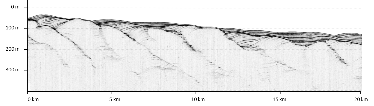
Sub-bottom data are also being collected during the Investigator’s transit and these data are supporting more conclusive geomorphic interpretations. Sub-bottom images reveal that many of the larger ridges are comprised entirely of rock, whereas others are draped in tens of meters of sediment that thicken laterally to fill intervening basins. Elsewhere along the route, relatively featureless planar surfaces are revealed by the sub-bottom images to be underlain by thick accretionary barforms that have more recently been buried by overlying, interbedded planar deposits (see figure below).
These geomorphic insights are useful for a range of marine sub-disciplines (e.g. benthic habitat mapping, seafloor stabiity analyses), and can be used to infer temporal variations in the strength of deep ocean currents, current pathways, rates of sediment supply and climate drivers. Similarly thick sediment drifts in the Cape Darnley field area will be characterised using high-resolution bathymetric grids and sub-bottom images to locate ideal sites to collect sediment cores. These cores are expected to have recorded hundreds of thosands of years of sediment accumulation and will be analysed to determine changes in palaeo-geomorphic processes as well as AABW behaviours in relation to glacial and interglacial climates.
More information about the voyage: